Sunday, May 30, 2010

Memorial Day Weekend Adventures with Dad and Peggy


Yesterday (Saturday: May 29, 2010), Dad, Peggy and I set out midmorning to go to Gilbertsville for a couple of hours. I thought they might like the "old time" feel to the town and the old stores.

First we stopped so I could check on a geocache in a cemetery just outside of Gilbertsville. Peggy found it, and then we cleaned it out really good and replaced it in its spot. We saw a really neat pink headstone that looks like it was made out of quartz. Picture up above. After that PeggyN found my geocache in the really old cemetery just down the road. This cemetery has gravesites of men who fought in the Revolutionary War. I think Dad, being a veteran himself, really liked this old cemetery. He said it was the first time he had seen a gravesite for someone who fought in the Revolutionary War.

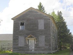
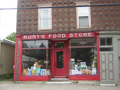
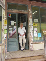
Then we went to Gilbertsville so Peggy could find my geocache OVERLOOK PARK. She found it quickly and I took a bunch of pictures. We went to the general store, the QUILT SHOP and to the Hardware Store. Dad bought a book at The Quilt Shop and a few items at the hardware store. I have noticed that Dad does not like having his picture taken unless it is at a place he really likes. He readily agreed to go back inside the hardware store and walk out so that I could take his picture in the doorway. That is the picture up above. He said he really thinks the hardware store has the original fixtures, etc. Being 85 years old, he has memories of what things looked like in what we sometimes refer to as "the old days".

While Dad and Peggy were in the hardware store I took a bunch more pictures of Gilbertsville to add to my Gilbertsville set on flicker. Of particular interest to Peg and me was the Hoosier cabinet that the owner of the Quilt Shop has in the back of her store. A picture is up above.

By this time, Dad was getting hungry and he suggested we find a restaurant. I had tons of food at home, so I suggested we head for my place. We stopped at the corner of Route 51 and Dimock Hollow Road so Peggy could find my Dimock "Hollow" geocache. I took some pictures of the falls and the views from the trail for flickr. We also walked across the street so Peggy could get a glimpse of All Saints Chapel. There was a wedding going on inside, so we did not walk up to it or go inside.

We had lunch at my house and Dad decided to take a nap. Peggy and I headed out for an afternoon of geocaching. First stop in Davenport Center, New York where we looked for a geocache in the Davenport Cemetery. We did not have any luck finding it, but the old cemetery sure is an interesting place. Flags had been placed on the
graves of men who gave their lives in past wars. Second stop was at Interskate 88 so we could look for SUSQHEHANNA VIEW geocache, one which I had looked for several times in the past. Peggy found it, and I was happy to scratch that off of my DID NOT FIND LIST.

Then on to Colliersville, were we found the geocache COLLIER'S DAM, and we attempted to find the one hidden at Bear Pond Winery. There was a musical event going on plus many people doing a wine tasting inside the gift shop as well as buying food from the outdoor cafe. We were really unable to look for the cache much because of so many people around, so we did not find it.

Back in Oneonta, we found Luckless's geocache hidden in the old cemetery which has a
monument saying SOLDIERS OF THE AMERICAN REVOLUTION and fresh flags.

Then we stopped by the bookstore on Chestnut Street to see if Peg had any ideas about the geocache hidden in IT WAS A DUCK AND STORMY NIGHT. We spent a few minutes without any success and then headed home.

It was a great day! The set of pictures I took for the entire day can be seen here: http://www.flickr.com/photos/juneny/sets/72157624172193162/


Monday, May 24, 2010

Three Adventurous Old Ladies go out on the town


New York Salvage
Originally uploaded by JuneNY
Connie asked me to help her take her mother out for the day. Her mother is elderly (she refuses to tell her age) and lives in a nursing home. It was a gorgeous spring day, but a little on the warm side. We agreed to meet at Wilber Park at noon and Connie said she would provide the picnic lunch. I arrived a bit early and walked what I call "the loop" twice before Connie's arrival. She brought indian food from THE PHOENIX CAFE. It was delicious!

After we finished our lunch we met up with Ann (Connie's mother" at the Fox Hospital Nursing Home. Then we went to NEW YORK SALVAGE, a business that buys up old things for resale. Ann was fascinated by the old kitchen and bathroom sinks in one of the barns. However, the sun was hot and the terrain was rough, so we had to quit after visiting that one barn. Their is a picture of Ann in that barn up on top.

After NEW YORK SALVAGE, we were trying to decide where to go. Ann thought we said THE DOLLAR TREE when we said THE ART GALLERY! It turned out that is where she really wanted to go, so we headed over to it. Ann had the best time. It had been six months since she had been able to shop for herself and she seemed to be cherishing the experience. I helped her find a few items.

We then went to the art gallery at the Wilber Mansion. I was not crazy about todays exhibits. I took the picture of the cobalt blue bottles. As we were leaving the mansion, Connie suggested that she might walk over to the HUNAN GOURMET and purchase some ice cream to go with the deserts she had purchased earlier. I helped Ann get settled into my car and we met Connie over at the HUMAN GOURMET. Ann joked about how she didn't know there was such a thing as Chinese ice cream.

We went back to the nursing home and had the indian desert (we never figured out what exactly it was, but it was good) and the Chinese ice cream! It was the prefect ending to a great day. It was so good to have the opportunity to put a smile on Ann's face, and to help Connie. I have a feeling both of them were as worn out by the day as I was!

Friday, May 21, 2010

Friday Geocaching Adventure


Luckless emailed me last night and asked if I was interested in doing some geocaching. I was free this morning, so I said yes. We agreed to meet up at her house at 9:30 a.m. We headed up to the SUCO COLLEGE CAMP to look for el fartero's geocache named OUT OF THIS WORLD. It was a quick easy find in a lovely wooded area, not far from the parking area. The cache had an outer space theme which fit the location, since it is very close to the SUCO Observatory.


We found that cache easily enough. It was huge, and very well stocked! Then we walked around the college camp a bit, and I, of course, took pictures for my flickr account.

Then we headed to the Colliersville area to look for a geocache named BRIDGE OVER DUCKY WATERS. It is a very tiny geocache hidden on an old one lane bridge on a back road. We looked for about twenty minutes without any success (a picture taken from the bridge is up at the top) and then we headed to another geocache just down the road called DUCKY DEAD END 2. We found this magnetic key case fairly quickly.

I had to work at three p.m. at the shelter, so I wanted to get home. We stopped at Arby's for a cold drink and then went to Leslies house. I got my car and headed home. It was a great morning.

More pictures can be see in my flickr set found here: http://www.flickr.com/photos/juneny/sets/72157623985374209/

Monday, May 17, 2010

Mini-Adventure with Connie


Umbrella Shaped Tree
Originally uploaded by JuneNY
Connie called me this morning and asked me to meet her at her place at ten a.m. to go on a "birdwalk" and then have lunch.

I arrived at the appointed time and we took off a few minutes later. The area she wanted to go on is part of a long stretch of trails that snowmobilers use. I had never been on it before. It was a perfect day to be outdoors!


We saw several birds: redwinged blackbirds, Baltimore Orioles, swallows, sparrows, robins and crows. Connie said it was not a good day for birding, but I was more than satisfied with what we saw. It was good practice using my binoculars, too.

I took some pictures for my flickr account: they are here:
http://www.flickr.com/photos/juneny/sets/72157623957348933/

After we were finished with our walk, Connie prepared a great lunch including homemade potato salad. We had a nice visit and I was home in time for a nap.

Saturday, May 15, 2010

Airport/Pleasant Brook/Cherry Valley/Jordanville/CooperstownADVENTURE!!!!


I read in the local Pennysaver that there was an "Old Airplane Fly-In" today. I decided that the idea of seeing some old planes sounded pretty good. I asked Carol M. if she was interested and she said she was. We met up at her apartment in Oneonta at ten a.m. today.


We headed out to the airport. (Someone at the Cooperstown Chamber of Commerce had given my directions over the phone the day before) When we got to the airport, we found out that the fly in had been cancelled due to the wind. Many people were at the airport, they seemed to be there for the pancake breakfast. Carol and I stuck around for about ten minutes and I took some pictures. The picture of the yellow plane up above was taken at the small airport.

On the way over to Cherry Valley, I stopped in Roseboom so Carol could see Bob's General Store. I bought a few postcards. We had seen a sign for a Maple Sugar House, so I asked for directions and was told how to get there from the store.

We missed the turnoff for the Maple Sugar House and ended up in an adorable hamlet known as Pleasant Brook. I took a bunch of pictures. We talked with a man who has spent a large portion of his life in Pleasant Brook and he told us about some of the buildings. We went to the Pleasant Brook Hotel and had lunch. Here is a picture of this neat old hotel:
It was the best quesadilla I have ever had! The bill for the two of us was only $5.50. The lady working the bar got permission from the owner for me to take some pictures. They still rent out rooms upstairs for $25.00 a night. The bartender did not seem to want me to go upstairs to look around, so I didn't.

After leaving Pleasant Brook, we located the Maple Sugar House, but it was closed.

Then we continued on over to Cherry Valley to see the Lilac Farm at the Hops House. We looked in the greenhouse and walked around the lilac bushes and I took some pictures.

After the lilacs, I found a parking spot in the downtown area. We went to an art gallery, Rury's Food Store, A ROSE IS A ROSE (flower shop) and I took a lot of pictures. Of special interest was the Civil War Memorial and NBT bank which is in an interesting old building.

We drove around Cherry Valley a bit and then we decided to take a different route back home. We ended up on Route 20 heading west. Soon, I recognized Route 31 which I knew was the way to get to the Amish area in or near Van Hornesville. We made a quick right and soon located the Amish run tack shop which I had been to before with Carol K. However, we decided to just continue driving to see what we might find.


We ended up in an interesting hamlet known as Salt Springfield. We saw an old empty
automotive shop, an old church and a restored barn that is used for community events. Here is a picture of the old abandoned shop.
We explored a bit and took pictures and then headed back up Rt. 31. We stopped at the tack shop. It was open and a young man was running it, with his tiny daughter by his side. We looked around and I bought some raisin clusters.

On the way back up to Rt 31 from the tack shop, we saw a sign for a shop called COUNTRY SELECTIONS. We located it and went in. It was in an Amish farm and they sell bulk food, non bulk food and all sorts of notions. A teenage Amish girl was running the store while we were there. I purchased a handmade bead necklace and some baking powder. I took several pictures of the farm. The farm is just beautiful and so meticulously taken care of. I think I may have visited this shop with Peggy several years ago.

After COUNTRY SELECTIONS, we headed back home, driving along the east side of Otsego Lake. I stopped in Cooperstown to show Carol the Indian Mound. Then back to Oneonta. As we approached Oneonta, Carol jokingly said she was starting to feel a little depressed at being back home.

It was a great day! My set of pictures are here: http://www.flickr.com/photos/juneny/sets/72157624068829366/

Friday, May 14, 2010

Cabin Fever Adventure!


Burlington, New York
Originally uploaded by JuneNY
My friend Connie and I had an outing planned for this afternoon.
A few minutes before we were planning to leave, she called and
said she was sick and could not make it. It was a gorgeous day and I had that "all dressed up and no place to go" feeling. Also, I had a touch of "cabin fever" and really felt I needed some fresh air and exercise.

So, I decided to take off on my own. I needed to check on a geocache that had been reported missing in Morris. So, I figured I would go do that, take a walk, and have my camera handy.


So, my first stop was the huge cemetery in Morris. I found the spot where I hid the cache a couple of years and indeed, it was missing. The tree stump I had hidden it in had deteriorated considerably over the winter, and most likely the cache was showing and someone found it and took it. Someone now has a very nice collection of buttons. I had a very tiny geocache all ready to go, so I replaced it, but in a different spot a few feet away from the where the original one was.

Then I headed towards Garratsville to check on the cache called CEMETERY WITHOUT A NAME. Just as I arrived, I saw artclasmodl leaving. I called out to her and we chatted for a few minutes. She had just found the cache and she said it was in fine shape. I stayed and took a few pictures of the cemetery, one of which is posted up at the top of todays blog entry.

I decided to continue on to Garrattsville to take a picture of the general store to add to my flickr group "THE GENERAL STORE". Once I got there, I realized I had plenty of time, so I decided to just continue driving straight to see what I might find that.

A few miles later, I found a very nice cemetery THE BUTTERNUT VALLEY CEMETERY. I decided to see if I could find a spot to hide a geocache. I did indeed find a nice spot, I hid it and took a few pictures. While in the cemetery I noticed a "ghost sign" on the back of a building right next to the cemetery. I took a picture. As I left, I checked out the building and it is a one story, two car garage. I have no idea why the sign (which looks rather new) is on the back of this garage.

I kept driving and ended up at a four corners which I think is Burlington or Burlington Flats. I took a picture of the Baptist Church and an old abandoned building and then headed back the way I came. I noticed a sign on a farm outbuilding saying STARVATION PLANTATION, which I thought was pretty cute, so I stopped and took a picture. The picture way at the top is Starvation Plantation.

After that I headed on home. I was glad to have a couple of hours in the sunshine and fresh air. My set on flickr for today can be found here: http://www.flickr.com/photos/juneny/sets/72157623937735479/

Saturday, May 8, 2010

Montgomery County Adventure


Early this morning, Linda and I set out for Auriesville, New York. She wanted to attend mass there. I had planned to walk around the shrine and take pictures while she was at mass, but it was raining, so I sat through the mass. The choir sang so beautifully, they sounded like angels! The second picture from the top is of the huge round chapel where they hold services and performances.

By the time the mass ended, the rain had stopped and the sky had cleared up. We did walk around for a few minutes, but it was lunchtime and both of us were getting hungry. We decided to drive to the Glen Store for lunch. I had seen pictures of this old country store on flickr. I accidentally gave Linda the wrong directions and we ended up in the Village of Fultonville instead of the hamlet of Glen in the TOWN of Fultonville. But no matter, I had a geocache programmed into my GPS and we stopped to find it. It was a quick and easy one.

Linda found our way back to the Glen Store. I had seem pictures of this place on flickr and decided it was a "must see". The real thing did NOT disappoint. You can see more pictures of the store here: http://www.flickr.com/photos/juneny/sets/72157623895691899/ It is a wonderful place. You can just imagine people sitting around the old pot bellied stove in the middle of the store a long time ago. I forgot to take pictures of the dining area which is on the left hand side of the pot belied stove. They provide lots of reading materials for customers, too. Linda and I both had the hot meatball sandwiches and iced tea for lunch.

Linda asked me if I wanted to go back to the Shrine of our Lady of Martyrs. I suggested that we return on a day when it is not wet, and after she has her hip surgery, so that walking is easier for her. I told her that what I really wanted to do was head back to I-88, but take our time and stop at places that look interesting. She agreed to that plan. I had seen several places that looked interesting on the way to the shrine and I was hoping to stop on the way back.
We passed one old cemetery, but it was on the wrong side of the road, so I told Linda to keep driving.

When we saw a sign for the CHARLESTON HISTORICAL SOCIETY, we took the road where the arrow was pointing. We ended up at an old church. The signs declared that it had been turned into the historical society. (see the third picture from the top for the picture of the old church which has been transformed into the historical society). There were a few cars around and the doors were opened, so we ventured in. We found out that the historical society was not really opened (it opens later on this month) and that they had just completed a presentation. We were invited in to look around and we were even offered refreshments which were abundant and home baked. Soooooooo, we did look around and I took pictures and we had some refreshments. Linda also bought two plants, one for each of us. Before leaving, we checked out the cemetery in the church yard, and we saw one stone for a Revolutionary War soldier.

Our next stop was when I noticed a very small cemetery along side the road. It almost appeared to be on the property of a trailer next door. It turned out to be the Davis Cemetery. A picture of the sign for the DAVIS CEMETERY is way up at the top. Most or all of the grave markers had the name DAVIS on them. I took a few pictures and we moved on.

That was our last stop. One problem is that Linda drives TOO darn fast! We passed a few more interesting spots, but it had started to rain, so I didn't ask her to turn around.

Now I want to go back to Fultonville to explore, back to the shrine to walk the entire grounds and also there is a natural spring located somewhere in the area that I would like to find. Lots of ideas for future day trips!!!

Friday, May 7, 2010

Training Day turned into an ADVENTURE!!


This morning, I attended a three hour training at Social Services in Cooperstown, New York. It was such a gorgeous day that my co-workers and I did not want to go back to work. Our boss who was driving went along with this idea. We had lunch at a cafe in THE COMMONS, a plaza just south of Cooperstown.

After that we headed to Cherry Valley to go to a place known as LILACS, LILACS, LILACS where there are a lot of lilac bushes and greenhouses where you can purchase
small bushes to transplant at home. This place is associated with the old building known as the HOPS HOUSE, and a picture of the Hops House is attached to this blog. After that, we decided to spend some time exploring Cherry Valley. We found the neatest book store. I noticed RURY'S FOOD STORE, and had to check it out.Once inside, I decided to buy something (batteries)befor asking if I could take pictures. Francis Rury still runs this true Mom and Pop store that has been in his family for a long time. The original shelving remains.

On the way back, I suggested that we might stop at another small Mom and Pop type store that I noticed on the way to Cherry Valley. Bob's Country Store in Roseboom is another great place, which offered a lot of photo opportunities. The Roseboom Post Office is located in this store.

Cherry Valley and Roseboom are places where I want to spend more time exploring in the future.

Wednesday, May 5, 2010

Four Hour Adventure with Terry May 5, 2010


When we realized that it was a beautiful day and we both had the afternoon free, Terry and I decided to go to the FrogPond and out to lunch. I asked her if she wanted to do some geocaching and she said yes.

We met up in Unadilla at 12:30 p.m. and headed to Bainbridge. We checked out the Olde Jericho Inn, but decided to have lunch at the S & S Cafe instead. We both had the pulled pork sandwich. We were a bit disappointed because it was somewhat dry.
A picture of the cafe is at the top.

As we were walking back to my car, Terry noticed a sign for an art show. We decided to check it out. The artwork was outstanding, but the best part was that the gallery is located in an old theatre in the Bainbridge town hall building.

Next stop was the Mennonite Store. I bought a few items.

Then on to THE FROGPOND, which did not disappoint. The prices were really good on most items. I spent eleven dollars and got an incredible amount of fresh vegetables and fruits.

Upon leaving The FrogPond, I fired up my GPS and gave it to Terry. She guided us
to the location of the cache, which is a wetland area near the school. We put on our boots and set out. Its a good thing we had the boots, there were a lot of wet and squishy spots. Terry found part one of the geocache. We opened it and there was a puzzle to solve. It was really hot and we decided we were too lazy to do the puzzle, so we trekked back to my van and took off.

On the way to Bainbridge, Terry had mentioned that we were not far from the East Guilford Cemetery where her husband is buried. We had plenty of time, so I suggested she show me where it is. Indeed, it was only a couple of miles away from
Route 7. Its a very small, but nice cemetery.

We headed back to Route 7 and towards Oneonta. I noticed what looked like an old abandoned grocery store so I suggested we stop and check it out the ALL AMERICAN PRODUCE GROCERY STORE. I guess it has a Sidney address, but there was a sign saying RIVERSIDE close by, so perhaps Riverside is a village or hamlet of Sidney. In a more recent life,this store was a flea market. Both the grocery store signs and the flea market signs remain, and I took a lot of pictures. Some of the flea market items are still sitting outside, in a partially enclosed area along the side and back. The third and fourth pictures up above are of the abandoned grocery store.

Terry suggested we stop for ice cream. We passed the first ice cream stand and ended up at THE BIG TOP (second picture from the top) I think we were still in Sidney. We both had waffle bowl sundaes and they just hit the spot. While eating our ice cream, we noticed a cute shop next door, which I took a picture of. We did not go in, but will save that for another time...... during another trip to Bainbridge.

We got back to Terry's car in Unadilla around 4:15 or so. We really packed a lot into a little less than four hours.

Sunday, May 2, 2010

10 Years! Oneonta, New York a geocache by softball29


The weather was perfect and we had a great turnout for the
geocaching event (bring your own picnic) at the lower level
pavilion in Wilber Park, in Oneonta, New York this afternoon.

Some of us made signs.......and this is me in the picture, holding the sign.

We all had chances at doorprizes, but I didn't win anything.

There were ten new geocaches available not too far from the
picnic site. I found one (Upper Level Cache) which involved
climbing up a pretty steep incline. It was harder climbing down, though.